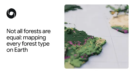
Forest mapping is an innovative approach that plays a crucial role in understanding and preserving the diverse forest types that make up our planet. This new mapping technique provides insights into the global forest typology, categorizing regions based on their ecological characteristics, such as naturally regenerating forests versus planted or plantation areas. As deforestation rates increase, monitoring these forest types is essential for effective deforestation tracking and conservation efforts. By distinguishing between different forest classifications, we can better assess the carbon storage abilities and biodiversity of each type. In a world where the health of our ecosystems is threatened, forest mapping serves as a vital tool for policymakers and environmentalists striving to protect our natural heritage.
Exploring the various classifications of woodland ecosystems, such as natural forests and cultivated tree farms, reveals a rich tapestry of ecological diversity. This practice of terrain cataloging is essential for determining how forests are utilized and maintained across the globe. By analyzing land-use patterns and changes, researchers can discern the distinctions between regenerative woodlands and intensively managed tree farms. The importance of mapping forest ecosystems cannot be overstated, as it provides a foundational understanding necessary for initiatives aimed at balancing conservation with agricultural needs. With advancements in geospatial technology, we can now better visualize and manage the shifts in our global forest landscapes.
The Importance of Forest Mapping in Conservation
Forest mapping plays a crucial role in understanding the complex ecosystems that make up our planet’s diverse forest types. With approximately 80% of the world’s terrestrial biodiversity residing in forests, accurate forest mapping helps conservationists and policymakers identify key areas for protection and restoration. By differentiating between natural forests, planted forests, and agricultural lands, stakeholders can allocate resources effectively to combat deforestation and promote biodiversity. The detailed Forest Typology (ForTy) map aids in this endeavor, offering insights into ecological health and informing strategies to safeguard these vital resources.
Moreover, forest mapping is essential in tracking changes over time, which is critical for assessing the impact of human activities on forest landscapes. The ForTy map categorizes land into six distinct forest types, enabling users to monitor shifts such as the conversion of natural forests into monoculture plantations. This level of detail is necessary for enforcing regulations, such as the EU’s deforestation-free products guideline, ensuring companies can trace their supply chains back to sustainable sources. Ultimately, comprehensive forest mapping empowers effective conservation efforts by providing actionable data.
How Forest Classification Aids Sustainable Practices
Understanding forest classification is vital for fostering sustainable practices in forestry and agriculture. By distinguishing between primary forests, naturally regenerating forests, and different types of plantations, stakeholders can make informed decisions that promote ecological health. For instance, knowledge about the ecological differences between a natural forest and a timber plantation is critical in determining the appropriate management practices that preserve biodiversity while meeting economic needs. By relying on the Forest Typology map, companies can better assess their environmental impact and adjust practices to align with sustainability targets.
Furthermore, accurate forest classification underpins effective deforestation tracking algorithms. With satellite-based mapping, stakeholders are equipped to identify illegal logging activities or land conversion trends that threaten forest ecosystems. By utilizing technologies that classify forest types and track changes, organizations can implement timely interventions. This proactive approach not only protects biodiversity but also supports sustainable land-use policies, helping economies transition towards green practices and fostering a balance between development and environmental stewardship.
The Role of AI in Forest Mapping
The integration of artificial intelligence (AI) into forest mapping marks a significant advancement in environmental science. The Forest Typology model employs sophisticated algorithms to analyze remote sensing data, enabling accurate classification of varying forest types. Through years of satellite observations, AI can discern subtle differences in land-use patterns, growth cycles, and harvest trends that traditional mapping methods may overlook. This technological leap enhances the precision of deforestation tracking, allowing for informed decision-making processes in conservation and land management.
AI developments facilitate not only the mapping process but also the creation of resilient data ecosystems that can adapt to changing environmental conditions. The Forest Typology (ForTy) map exemplifies this innovation, as it utilizes a vast database of labeled forest types compiled from expert knowledge and diverse datasets. By continually updating and validating the model, stakeholders can maintain an accurate picture of forests worldwide, enabling swift responses to threats such as deforestation and habitat loss. Such AI-driven insights empower conservationists to adopt preventative measures, bolster biodiversity initiatives, and significantly contribute to global sustainability efforts.
Understanding Global Forest Typology
Global forest typology is an essential component of understanding environmental landscapes and the nature of forestry practices worldwide. By categorizing forests into classes such as primary, naturally regenerating, planted, and plantation forests, researchers and practitioners gain a clearer picture of the world’s forest biodiversity and health. The systematic classification provided by the Forest Typology (ForTy) map does more than just catalog forests; it aids in establishing benchmarks for conservation efforts, allowing for targeted interventions based on specific forest characteristics.
Such differentiation is critical as forests play varied roles in carbon sequestration and provide diverse habitats for countless species. For example, primary forests, which have developed naturally over long periods, typically store more carbon and support greater biodiversity than managed plantations. Understanding these distinctions reinforces the need for tailored conservation strategies that recognize the unique contributions of each forest type to global ecological stability. Consequently, global forest typology serves as a foundational tool in both research and practical applications for sustainable forestry.
Using Forest Mapping for Deforestation Tracking
Deforestation tracking has become imperative in the context of climate change and biodiversity loss. Accurate forest mapping provides the necessary data to identify and monitor land-use changes that indicate deforestation. The Forest Typology (ForTy) model enhances this capability by offering a mapped representation of not just where forests exist, but what types they are and how they evolve over time. This level of detail is crucial for policymakers, conservationists, and businesses striving to develop deforestation-free supply chains.
Moreover, the ability to track deforestation at a granular level, such as the 10-meter resolution for each pixel included in the ForTy map, allows stakeholders to understand the complexities of forest loss and regrowth dynamics. This information is crucial for developing effective strategies to combat illegal logging and land conversion to agriculture. By monitoring these changes, regulators and conservationists can respond rapidly and efficiently to mitigate environmental impacts, ultimately contributing to global efforts to maintain forest ecosystems.
Natural vs. Planted Forests: Key Differences
Understanding the differences between natural and planted forests is paramount for effective forest management and conservation strategies. Natural forests, typically composed of diverse native species and developed over centuries, offer rich biodiversity and greater carbon storage capabilities compared to planted forests, which are often monocultures introduced for commercial purposes. The Forest Typology (ForTy) map illustrates these distinctions, allowing stakeholders to assess the ecological functions of different forest types and their roles in climate regulation and biodiversity support.
Recognizing these differences is vital in designing and implementing sustainable forestry practices. For instance, while planted forests might provide short-term economic advantages, they often lack the resilience and ecological benefits associated with natural forests. By using current mapping technologies to monitor and manage forest types, stakeholders can promote reforestation initiatives that favor the restoration of natural ecosystems over simplistic plantations. This focus on natural forests contributes not only to biodiversity conservation but also to long-term climate mitigation efforts.
The Future of Forest Monitoring
The ongoing evolution of forest monitoring techniques, particularly through technological advancements like AI and satellite imagery, promises a future where conservation efforts can be sharper and more data-driven. The Forest Typology (ForTy) map sets a benchmark for how detailed assessments of forests can guide future projects aimed at sustainability and ecosystem protection. As data collection improves, we will be able to track changes in forest types with unprecedented accuracy, fostering a better understanding of how our forests respond to human pressures and environmental changes.
Additionally, the collaborative nature of current conservation efforts, combining expertise from tech firms, research institutions, and environmental organizations, encourages innovative methods for monitoring and protecting forests. The integration of datasets across various disciplines can lead to a holistic view of forest dynamics—an essential tool in the fight against climate change and biodiversity loss. By continually improving forest mapping practices, we can ensure that future generations inherit a world rich in forest diversity and ecological balance.
Engagement in Forest Conservation Efforts
Engagement in conservation efforts is crucial for the sustained health of our forests. The detailed insights provided by forest mapping, including those from the ForTy model, empower grassroots movements, governments, and NGOs to advocate for policies that protect our natural resources. Effective engagement fosters a collaborative approach to addressing the threats facing forests, informing community members and stakeholders about the importance of forest types and their myriad ecological benefits.
Moreover, raising public awareness about forest variability and the consequences of deforestation drives community involvement in conservation initiatives. Programs that educate the public on the significance of preserving natural forests can inspire action at local, national, and global levels. This heightened awareness, coupled with data-backed advocacy, can lead to stronger policies and successful conservation management practices aimed at safeguarding the diverse ecosystems that are crucial for planetary health.
Final Thoughts on Forest Management
As we face the challenges of climate change and biodiversity loss, emphasizing effective forest management practices grounded in accurate mapping becomes increasingly important. The Forest Typology (ForTy) represents a significant advancement in our ability to categorize and monitor forest types. By providing clear distinctions between natural and planted forests, as well as tracking changes over time, we can better inform conservation efforts aimed at protecting these vital ecosystems.
Ultimately, a robust understanding of global forest typology is foundational to addressing not only the immediate threats of deforestation but also ensuring long-term sustainable practices. By leveraging innovative mapping technologies and fostering strong partnerships across sectors, we can enhance our capabilities in protecting forests, fostering biodiversity, and combating climate change for generations to come.
Frequently Asked Questions
What is forest mapping and why is it important for understanding global forest typology?
Forest mapping refers to the process of identifying and categorizing different types of forests, such as primary forests, naturally regenerating forests, planted forests, and plantation forests. It is crucial for understanding global forest typology because it helps in tracking changes in forest cover, assessing biodiversity, and evaluating carbon storage capacity. By utilizing detailed satellite imagery and data analytics, forest mapping provides insights into the health and status of forests, guiding conservation efforts and informing policies aimed at reducing deforestation.
| Forest Type | Description | Ecological Value | Management Implications |
|---|---|---|---|
| Primary Forest | Native forest with no visible signs of human disturbance. | High carbon storage and biodiversity. | Critical for conservation efforts; highly protected. |
| Naturally Regenerating Forest | Forest that regrows on its own after disturbance like logging. | Moderate biodiversity; depends on regeneration history. | May require management to maintain species diversity. |
| Planted Forest | Forests planted and managed by people. | Lower biodiversity; ecological benefits depend on practices. | Requires consistent management practices. |
| Plantation Forest | Intensively managed tree farms, often monocultures. | Low biodiversity; high carbon capture potential. | Focus on productivity; environmental impacts must be monitored. |
| Tree Crops and Agroforestry | Farms growing non-timber crops like cocoa or rubber. | Varies widely; can enhance biodiversity if well managed. | Potential for sustainable land use and conservation. |
| Other Land | Land that does not primarily function as forest. | No ecological forest value. | Includes areas for human activity; management insignificant. |
Summary
Forest mapping plays a crucial role in understanding global ecological dynamics and conservation strategies. By utilizing advanced tools like the Forest Typology (ForTy) 2020, we can classify forests into various types and monitor their changes over time, addressing the essential need to know what type of forest is present, be it natural, planted, or cultivated. This detailed insight not only helps in conserving biodiversity but also aids regulatory frameworks in ensuring the sustainability of forest resources. As we continue to leverage modern technology for forest mapping, we gain a more comprehensive view of the ecological tapestry of our planet, allowing for informed decisions that directly impact forest health and biodiversity.